The Waikato runs from the Coromandel coast in the north-east to the King Country in the south, with Hamilton and the river down the middle. It is farmland, mostly — but it is farmland with a surf coast on one side and a limestone cave system underneath part of it.
The five parts of the region
Hamilton and the river
The hub. The hospital, the university, the airport and most of the region’s jobs. Built along both banks of the Waikato, with the older suburbs east and the newer growth north.
The Waipa towns
Cambridge and Te Awamutu, south of the city. Cambridge is the country’s equine centre and probably its prettiest small town; Te Awamutu is plainer and considerably cheaper.
North Waikato
Ngāruawāhia, Huntly and Te Kāuwhata, running towards Auckland. Ngāruawāhia is the seat of the Kīngitanga; the whole corridor is growing quickly as Auckland pushes south.
The west coast
Raglan and the black-sand harbours. Forty-five minutes from Hamilton and a completely different pace — surf, art, and a village that has resisted being tidied up.
The Coromandel and the south
Thames and the peninsula to the north-east; the King Country, Waitomo and Te Kūiti to the south. Rural, spectacular, and where much of the region’s rural health work sits.
The climate
Warm, humid and green. Summers are warm and often muggy; winters are mild by any northern-hemisphere standard, with frosts inland but rarely anything severe. Rain is spread through the year rather than arriving in bursts, which is exactly why the region looks the way it does.
The distinctive local feature is fog. On still autumn and winter mornings the river flats fill with mist that can sit until mid-morning. It is atmospheric, it slows the motorway, and after a season you stop noticing.
Summer
Dec – Feb
22–26°C
Warm and humid, with long evenings. The coast is the obvious escape, and everyone takes it.
Autumn
Mar – May
15–22°C
Often the best season — settled, warm days and cool nights. The fog starts appearing in May.
Winter
Jun – Aug
7–15°C
Mild, damp and grey. Frosts inland, rarely snow. The main adjustment is the lack of bright days rather than the temperature.
Spring
Sep – Nov
12–20°C
Changeable and increasingly green. Lambs, blossom, and the region at its most photogenic.
Distances that matter
Auckland
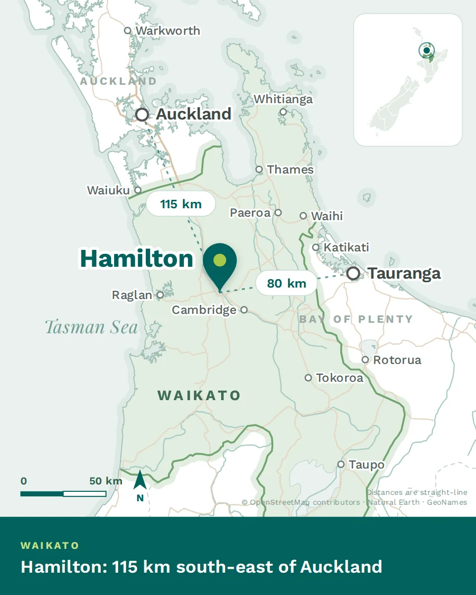
90 minutes on the expressway to the city centre; a little over an hour to the airport’s southern approaches.
The coast
Raglan 45 minutes west. Thames and the Coromandel about 90 minutes north-east. Tauranga an hour east.
The lakes and the volcanoes
Rotorua an hour, Taupō two, the central plateau and the ski fields around three and a half.
Within the region
Cambridge 20 minutes, Te Awamutu 30, Ngāruawāhia 20, Te Kūiti an hour, Thames 90 minutes.
The river, and why it matters
The Waikato is the longest river in New Zealand, and Hamilton is built on a bend of it. That sounds like geography-lesson detail until you live here, at which point it becomes the thing that organises the city.
Practically: the river splits Hamilton in two, and the bridges matter. Working out which side of the water the hospital is on relative to your shortlist of houses will save you a lot of irritation later. The river walkways are also the city’s best amenity — continuous paths for miles in both directions, used by everyone, and the reason a lot of people run or cycle here.
Beyond the city the river is the region’s spine, running north from Taupō through the hydro lakes and out to the west coast at Port Waikato. Much of the Waikato’s history, its iwi, and its farming wealth trace that line.
Four parts of the region
Where Hamilton sits, with the straight-line distance to Auckland and Tauranga
Hamilton
Around 185,000 people on the river, and one of the youngest and fastest-growing cities in the country. The hospital, the university, and the region’s services are all here.
The satellite towns
Cambridge, Te Awamutu, Ngāruawāhia, Morrinsville, Te Kauwhata. Real towns with their own high streets, fifteen to forty minutes out, popular with families for space and character.
The west coast
Raglan and the black-sand surf beaches, forty-five minutes over the hill. A different world from the farmland — surf culture, cafés, and the reason a lot of people move here.
The wider region
The King Country and Waitomo to the south, the Coromandel to the north-east, Rotorua and Taupō within ninety minutes, and Mount Ruapehu two and a half hours. This reach is the region’s real argument.
A few local notes
On the fog. The Waikato basin traps cold air on still autumn and winter mornings. It usually clears by mid-morning, but it affects driving and occasionally flights.
On the humidity. Summers here are warm and muggy rather than dry. Houses need ventilation as much as heating.
On the river. The Waikato is the longest river in New Zealand and it shapes the city — walkways, bridges and which side of it you live on.
The thing to hold on to
The Waikato’s advantage is position. You are ninety minutes from Auckland, an hour from the Bay of Plenty, forty-five minutes from a surf coast, and living in the middle of it for a fraction of what any of those cost.